Sustainable Groundwater Management Act (SGMA) in Solano County*
Frequently Asked Questions
DOMESTIC WELLS
Are you going to put meters on wells?
At this early stage of SGMA implementation, we don’t know what tools will be used locally to monitor and ensure sustainable groundwater use. SGMA provides an array of regulatory and non-regulatory tools – mostly optional – from which Groundwater Sustainability Agencies (GSAs) can choose to achieve and monitor groundwater sustainability. The local GSAs will have to decide which tools they will use, and well metering could be one such tool. Because the GSAs are seeking to develop a single Groundwater Sustainability Plan (GSP), they will need to collect sufficient data on groundwater conditions in order to demonstrate progress toward achieving the sustainability goal and measurable objectives, but this doesn’t necessarily mean that all wells must be metered. SGMA requires that public stakeholders be engaged in the development and implementation of the Groundwater Sustainability Plan, which will allow additional opportunity for interested stakeholders to provide input on this issue.
Much of the groundwater delivered by local agencies is already metered, and other data sources (such as land use data) provide solid information to estimate groundwater use.
Do domestic well users have to comply with SGMA?
Wells pumping less than 2 acre-feet per year (1,785 gallons per day) for domestic use are considered to be “de minimis” and could be exempt from most SGMA requirements. This includes exemption from metering, reporting requirements, and fees. Most private, non-agricultural wells will fall into this “de minimis” category. The Department of Water Resources (DWR) created a leaflet that explains this further.
Can I drill my well deeper or put in a new well?
In Solano County, a permit is required to construct, repair or destroy a water supply, monitoring or cathodic protection well or soil boring. Well permit applications and requirements can be obtained by contacting the Solano County Department of Resource Management, Environmental Health Division at 707-784-6765, or RMHelp@solanocounty.com.
You can also visit the Solano County Department of Resource Management’s web page for more information about Environmental Health and its Well Program.
For information on drilling wells in Yolo County, click here.
For information on drilling in Sacramento County, click here.
Does historical pumping have an impact on how much is allowed to be pumped in the future?
It is too early to tell what pumping restrictions, if any, will occur in the Solano Subbasin. If water budget data indicate that the subbasin is being managed in a sustainable manner, then changes to current pumping regimes should be fairly limited. It may be determined that some areas in the subbasin do not meet the sustainability criteria and may be managed differently than the rest of the subbasin.
How do deeper wells from cities, irrigation Districts, or agricultural users affect my shallower domestic well?
Over the long term, implementation of SGMA is intended to make all groundwater users in the Solano Subbasin more resilient to future droughts and to help ensure adequate water supplies are available for all present and future users. Most domestic wells are shallower than wells used by cities and irrigation Districts. Water levels in shallow domestic wells may be impacted if an agency’s well and a domestic well are too close together. However, other aspects that may influence water levels in wells include: well construction, which aquifers neighboring wells are drawing from, soil types, pumping rates, and distances from surface water sources and other wells. Questions about a local well should be addressed to the well owner or agency.
SGMA requires the GSP to determine and maintain the sustainable yield of the Subbasin. Under SGMA, a GSP must ensure that groundwater extraction does not lead to chronic lowering of groundwater levels or other undesirable results.
STAKEHOLDER PARTICIPATION IN SGMA IMPLEMENTATION
Do I have to share my private well data with the GSAs?
While the existing groundwater monitoring network is quite robust, there are some data gaps in some parts of the Solano Subbasin. It is likely that the Solano Collaborative may ask landowners to volunteer to have data collected at some wells to enhance our knowledge of groundwater conditions in the subbasin. This would likely not require any expenses on behalf of the landowner as the GSAs would use their equipment to monitor the groundwater levels in a landowner’s well.
How can I share my private well data with the GSAs?
If you are interested in sharing data with local public agencies, please contact Chris Lee at the Solano County Water Agency (clee@scwa2.com, 707-451-6090). The GSAs welcome such data as it can help fill in gaps in the existing monitoring network.
How can I participate?
There are many ways for you to get involved. An email list-serv and informational website provide information regarding the Solano Subbasin and the SGMA process, including opportunities for public participation and upcoming workshops and events.
Use this page to sign up for the newsletter and view upcoming events and keep in touch with the GSAs and agencies listed here:
- Resource Conservation Districts
- Reclamation Districts
- Solano Irrigation District
- Cities of Vacaville, Dixon, and Rio Vista
- Solano County Farm Bureau
- Solano County Water Agency
- Solano, Sacramento, and Yolo Counties
- Solano County Agricultural Advisory Committee
Where can I sign up to be on the email list to receive updates on SGMA implementation?
Sign up for the email list at the top of this page or by emailing Guadalupe@aginnovations.org with the subject: “Join SGMA Listserv.” This website also contains local information, downloadable factsheets, and links to state and other resources.
GROUNDWATER SUSTAINABILITY PLAN FUNDING
The Solano GSA Collaborative has determined that GSP implementation costs (not including projects and management actions) can be funded through the GSA Proposition 218 Fee setting process. This will ensure that all GSAs pay their share of GSP implementation costs.
Does state funding exist to help with SGMA and GSP planning and implementation?
The Solano Collaborative will be pursuing additional grant funds through the upcoming SGMA implementation funding cycle to support eligible Solano Subbasin GSP implementation costs. The GSA Collaborative will continue to evaluate and pursue other grant funding sources as they become available.
How will fees for landowners be determined?
All landowners in the Solano Subbasin are subject to charges to support GSP implementation. Charges are based on groundwater use in each GSA service area. Under the Sustainable Groundwater Management Act (SGMA), Federal, State, and Tribal lands are exempt from charges.
How will the GSAs fund implementation activities?
GSAs are managing at a local level, with the goal of keeping costs down. The Solano GSA Collaborative has determined that GSP implementation costs (not including projects and management actions) can be funded through the GSA Proposition 218 Fee setting process. This will ensure that all GSAs pay their share of GSP implementation costs. The Solano GSA Collaborative has determined that GSP implementation costs (not including projects and management actions) can be funded through the GSA Proposition 218 Fee setting process. This will ensure that all GSAs pay their share of GSP implementation costs.
Why would landowners be responsible for groundwater fees?
The Solano Collaborative is working to keep costs down, including pursuing state and local agency funding. However, the GSAs will be imposing charges upon landowners to cover the cost of preparation and implementation of the GSP. Because SGMA requires a GSP to be prepared for the entire basin, all landowners will share in the cost of compliance.
Will cities help pay for the GSP?
All landowners in the Solano Subbasin (except the Federal, Tribal, and State lands exempted by SGMA), including cities, will help pay for the GSP implementation costs.
Will fee structuring have to be uniform across the subbasin?
Each GSA will pay its fair share of GSP implementation costs, and each GSA will determine the method for distributing those costs.
GROUNDWATER SUSTAINABILITY AGENCIES
Can multiple GSAs create a single GSP for the subbasin?
Yes, multiple GSAs can work together to develop a single subbasin-wide GSP. Multiple GSAs could also develop multiple GSPs that cover the entire subbasin. If multiple GSPs are developed, GSAs must create a “coordination agreement” specifying their roles and responsibilities, and outlining procedures for the timely exchange of data and the resolution of conflicts. Each GSP must utilize the “same data and methodologies” to establish criteria for overall management of the entire subbasin. If multiple GSPs are prepared, the GSAs shall jointly submit the GSPs to DWR by January 31, 2022, explain how the GSPs when implemented together will satisfy all the GSP requirements, and provide the coordination agreement.
How will the agricultural community be represented in the SGMA process?
It was important early on to include multiple entities and individuals who represented the agricultural community into the SGMA, GSA formation, and now GSP development process. Landowners, farmers, ranchers, and other stakeholders are represented on most of the GSAs developing the GSP for the Solano Subbasin. For more information, click on the Solano Collaborative tab at the top of the page.
What authority does a GSA have?
SGMA gives GSAs numerous new tools and authorities to manage the groundwater and implement the objectives of the GSP. These include the authority to conduct investigations, determine the sustainable yield of a groundwater basin, measure and limit extraction, impose fees for groundwater management, and enforce the terms of a GSP. These authorities can be implemented by one or multiple GSAs. Chapter 5 of SGMA describes the powers and authorities in greater detail.
What agencies can form a GSA?
A GSA-eligible agency is any local public agency that has water supply, water management, or land use responsibilities within the Solano Subbasin. These include: water agencies, cities, counties, reclamation districts, and resource conservation districts. A water corporation regulated by the California Public Utilities Commission or a mutual water company may participate in a GSA through a memorandum of agreement or other legal agreement.
What does a GSA do?
The primary purpose of a GSA under SGMA is to develop and implement a Groundwater Sustainability Plan (GSP) to achieve long-term groundwater sustainability. GSAs are empowered to utilize a number of new management tools to achieve the sustainability goal, such as: register and meter groundwater wells, mandate annual extraction and water level reports from individual wells, impose limits on extractions, mitigate against overdraft, implement rules and regulations, and assess fees to support creation and implementation of a GSP.
GROUNDWATER SUSTAINABILITY PLAN (GSP)
What is a GSP?
A Groundwater Sustainability Plan (GSP) is the state-mandated plan to sustainably manage groundwater. Each GSP will contain an assessment of each basin, measurable objectives that are specific, and quantifiable goals for the maintenance or improvement of specified groundwater conditions that have been included in an adopted Plan to achieve the sustainability goal for the basin. The GSP will also include any necessary monitoring, management, enforcement, and other requirements to achieve and/or maintain sustainability.
What are required elements of a GSP?
The Solano Subbasin GSP will be developed by the efforts of the Solano Collaborative, made up of the GSAs overlying the Solano Subbasin, as well as from all interested stakeholders. Required elements of the GSP are:
- A description of the physical setting and characteristics of the aquifer system underlying the basin, including:
- Historical data
- Groundwater levels, groundwater quality, subsidence, and groundwater-surface water interaction
- Historical and projected water demands and supplies
- A map of the basin area and the boundaries of the groundwater sustainability agencies that overlie the basin
- A map identifying existing and potential recharge areas for the basin
- Measurable objectives to achieve the sustainability goal in the basin within 20 years of the implementation of the plan, including interim milestones.
- How the plan helps meet each objective
- How each objective is intended to achieve the sustainability goal
- A planning and implementation horizon
- Information about the following, as applicable:
- The monitoring and management of groundwater levels within the basin.
- The monitoring and management of groundwater quality, groundwater quality degradation, inelastic land surface subsidence, and changes in surface flow and surface water quality that directly affect groundwater levels or quality or are caused by groundwater extraction in the basin.
- Mitigation of overdraft.
- How recharge areas identified in the plan substantially contribute to the replenishment of the basin.
- A description of surface water supply used or available for use for groundwater recharge or in-lieu use.
- A summary of existing monitoring efforts, including site types, measured data, and monitoring frequency. These include all locations monitoring groundwater levels, groundwater quality, subsidence, streamflow, precipitation, evaporation, and/or tidal influence.
- Monitoring protocols for detecting changes in groundwater levels, groundwater quality, and flow and quality of surface water that are linked to groundwater levels, quality, or extraction.
- An assessment of how the GSP may affect applicable county and city general plans, as well as the various adopted water resources-related plans and programs within the basin.
More detailed requirements are identified in Section 10727 of the California Water Code.
What are undesirable results?
Undesirable results means one or more of the following effects caused by groundwater conditions occurring throughout the basin:
(1) Chronic lowering of groundwater levels indicating a significant and unreasonable depletion of supply if continued over the planning and implementation horizon. Overdraft during a period of drought is not sufficient to establish a chronic lowering of groundwater levels if extractions and groundwater recharge are managed as necessary to ensure that reductions in groundwater levels or storage during a period of drought are offset by increases in groundwater levels or storage during other periods.
(2) Significant and unreasonable reduction of groundwater storage.
(3) Significant and unreasonable seawater intrusion.
(4) Significant and unreasonable degraded water quality, including the migration of contaminant plumes that impair water supplies.
(5) Significant and unreasonable land subsidence that substantially interferes with surface land uses.
(6) Depletions of interconnected surface water that have significant and unreasonable adverse impacts on beneficial uses of the surface water.
GSPs must address these issues and have actions in place to offset any adverse impacts associated with these undesirable results.
What is the timeline for GSP submittal?
The Solano Subbasin is a medium priority subbasin. The Solano GSP was submitted to the California Department of Water Resources (DWR) Jan. 31, 2022.
GROUNDWATER IN THE SOLANO SUBBASIN
How do groundwater levels vary year to year?
Groundwater levels vary seasonally and based on location in the Solano Subbasin. Groundwater is generally closest to the land surface in the relatively shallow aquifer zones (including alluvial deposits and the upper zone of the Tehama Formation, see below for explanation of aquifer zones). Shallow aquifer zones are more often relied on by private residences, agriculture, and natural communities. Over the last 30 years, monitoring data show that average depths to groundwater in shallow aquifer zones in spring have been between 15 feet and 35 feet below ground surface. In the fall, average depths to ground water in shallow aquifer zones have been between 15 feet and 45 feet below ground surface. In some areas, such as near the Delta, groundwater is commonly less than 10 feet from the land surface. Deeper aquifer zones (including the middle and basal zones of the Tehama Formation) typically utilized by municipal water systems, have had average depths to groundwater of about 140 feet in spring and about 150 feet in the fall. Groundwater levels in the deeper aquifer zones are not observed to influence groundwater levels in shallow aquifer zones. Information regarding water levels can be viewed on DWR’s Groundwater Monitoring website and at the Solano County Water Agency.
How much groundwater is in the Solano Subbasin?
We don’t currently know, but will have more information in a few years. While groundwater levels throughout the Solano Subbasin have been monitored over time, the total quantity of groundwater within the subbasin has not been determined. Since implementation of the Solano Project, which brought water from Lake Berryessa, we haven’t had a documented groundwater issue. Thus, while the Solano County Water Agency has tracked groundwater levels in the Solano Subbasin, until the SGMA legislation was passed, we didn’t have a specific reason to analyze the useable amount of groundwater in storage. We will now dedicate more resources to groundwater monitoring and developing models and a water budget, so we’ll have more information in a few years. Through future studies, groundwater monitoring, and modeling, we will develop a better understanding of groundwater resources in the subbasin.
Is the aquifer level synonymous with the water table? Sometimes. The term water table has a specific meaning in groundwater hydrology. In alluvial groundwater basins such as Solano Subbasin, groundwater occurs mainly in porous and permeable unconsolidated sediments composing an aquifer system. Water moves most easily through permeable coarse-grained deposits of sand and gravel and much more slowly through finer-grained deposits of silt and clay. Fine-grained materials typically restrict groundwater flow and can separate groundwater in coarser-grained aquifers that underlie or overlie them. Confined aquifers under pressure have water levels that are higher than the upper surface of the aquifer. Confined groundwater is not synonymous with the water table. If saturated permeable deposits are not overlain by confining materials, they are termed unconfined and are open to the atmosphere via the unsaturated zone, and to direct infiltration from the land surface. Groundwater levels measured in the unconfined part of the aquifer system are synonymous with the water table.
Source: https://water.usgs.gov/edu/graphics/gwflowproblems2.gif
Is groundwater quality currently being monitored?
Community water systems, such as those serving municipalities, are required by state law to monitor the quality of the water they supply to the public. Small water systems, such as schools, mobile home parks, and food facilities that use groundwater wells to supply their drinking water are also required by the state to monitor water quality. Other state programs require groundwater quality monitoring for locations near regulated facilities (an example of a type of regulated facility includes leaking underground fuel tanks). A statewide database through State Water Resources Control Board Groundwater Ambient Monitoring and Assessment Program (GAMA) Program integrates and displays groundwater information.
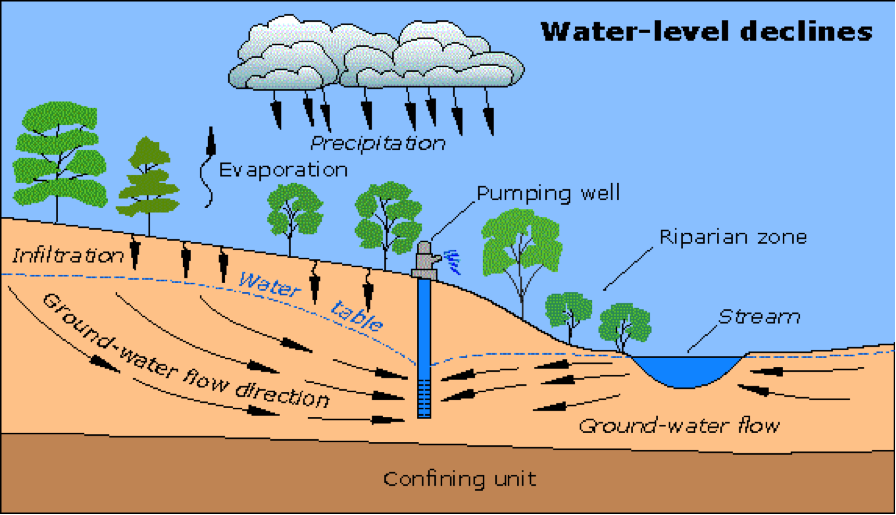
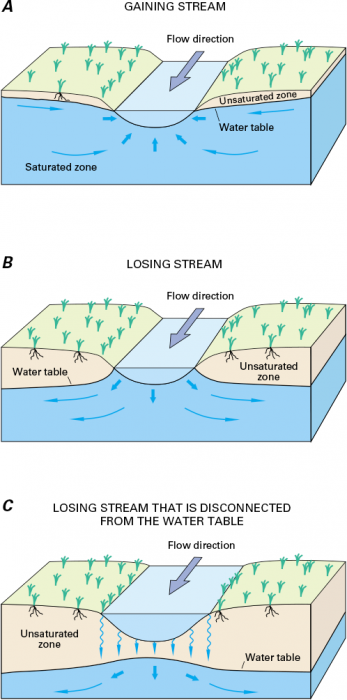
Is there a link between groundwater and surface water, and if so, how will it be managed?
In general, there are linkages between surface water and groundwater. Understanding the spatial and temporal interconnection between surface water and groundwater is a requirement of the GSP and appropriate management actions will be included in the Plan.
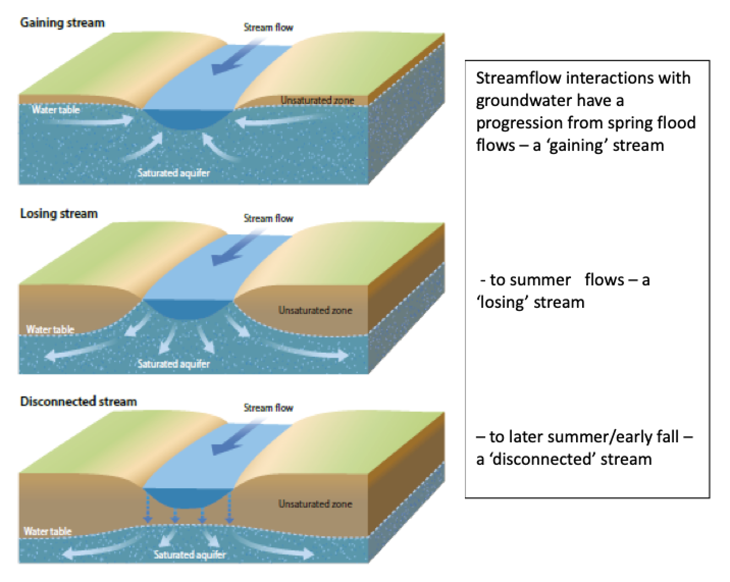
Source: E-Education
What are the names of the different aquifer layers and what are their depths?
An aquifer is geologic material (rock or sediment) that is sufficiently porous and permeable to store, transmit, and yield significant or economic quantities of groundwater to wells and springs. Within Solano County, there are two major aquifers in the Solano Subbasin, the alluvium (including the Putah Fan) and the Tehama Formation. The alluvial deposits may be up to several hundred feet thick, and these occur throughout most of the subbasin. The deeper Tehama Formation has multiple depth zones where groundwater occurs and extends to the base of the freshwater to depths of several thousand feet. Most private rural domestic groundwater is pumped from alluvial deposits. The agencies drawing groundwater from the Tehama Formation include the Cities of Dixon and Vacaville, Cal Water Services in Dixon, Solano Irrigation District, and Rural North Vacaville Water District.
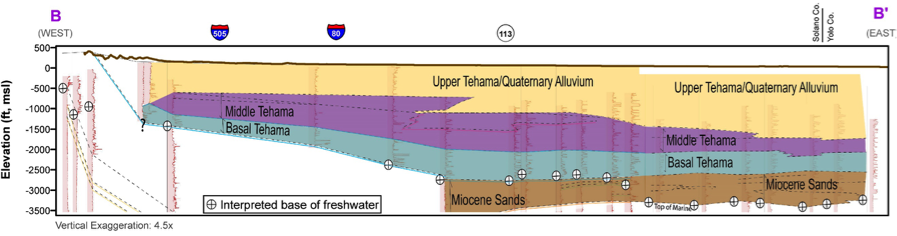

Source: Luhdorff & Scalmanini
What is a water budget?
A “water budget” is the accounting of the total groundwater and surface water entering and leaving a basin, including the changes in the amount of groundwater stored in the basin. Basic components of water budgets are:
- Precipitation (rain)
- Evapotranspiration (a combination of evaporation from the soil and transpiration by plants)
- Surface water flow (streams and lakes) infiltrating or leaving the groundwater basin
- Groundwater flow (aquifers) into and out of the groundwater basin
- Change in groundwater storage
- Groundwater pumping and consumed or exported from the basin.
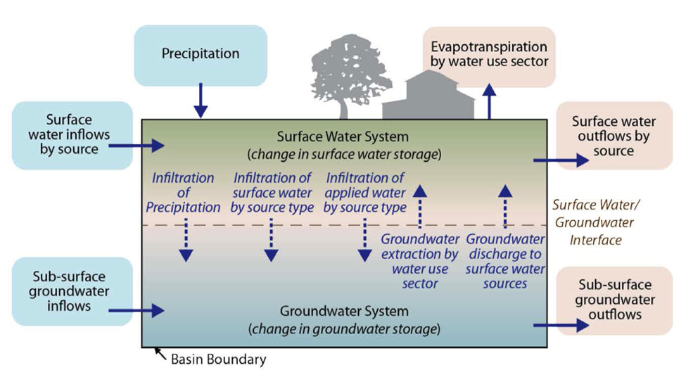
Source: California Department of Water Resources
What is irrigation system efficiency and what factors affect the efficiency?
Irrigation system efficiency is a ratio of the amount of irrigation water consumed by plants to the total amount of irrigation water supply. The irrigation efficiency depends on a variety of factors, including topography, soil characteristics, water conveyance system, crop type, and irrigation practices.
What percent of groundwater is pumped for agricultural users?
We don’t know exactly what percentage of total groundwater use is for agriculture. Unlike cities and water agencies that are required to report their water use to the state, private well owners, including farmers, are not required to report how much groundwater they pump. Local UC Cooperative Extension and Conservation District specialists estimate that agriculture may use up to 90% of groundwater pumped in Solano Subbasin. Groundwater studies that are underway as part of the Plan will help clarify the amount of groundwater used by various sectors, including agriculture.
Why are there different groundwater conditions in different parts of the Solano Subbasin?
There are a variety of surface (e.g., land use associated demands, surface water imports, climate factors) and subsurface (e.g., geology) conditions that influence groundwater conditions throughout the subbasin. Groundwater levels and trends can vary in response to these many variables. Generally, if more groundwater is pumped from a part of the aquifer system than can be replenished, then groundwater level declines may be observed. Such trends may be seasonal and temporary, or they may be longer term should extraction exceed replenishment over an extended period of years, generally not including drought-type conditions. Groundwater level trends are important in a SGMA context; see also the definition of Undesirable Results.
SGMA & SOLANO SUBBASIN OVERVIEW
How will SGMA projects be evaluated for environmental impacts?
SGMA explicitly exempts Groundwater Sustainability Plans from evaluation under the California Environmental Quality Act (CEQA). However, GSAs will need to evaluate and mitigate any environmental impacts from any projects or management actions that they determine are required to reach sustainability.
What is the purpose of SGMA?
SGMA exists to ensure sustainable management of groundwater resources. There are six undesirable results that SGMA requires GSAs in each medium and high priority subbasin to prevent:
- chronic lowering of groundwater levels
- reduction of groundwater storage
- degraded water quality
- land subsidence that substantially interferes with surface land uses
- sea water intrusion
- depletion of surface water that have adverse impacts on beneficial uses of surface water
What is the Solano Collaborative?
In 2017, four of the GSAs within the Solano Subbasin (City of Vacaville GSA, Sacramento County GSA, Solano Irrigation District GSA, and the Solano GSA) entered into an agreement to cooperatively implement SGMA. The goal of the agreement was to evaluate cost-effective strategies to develop a Groundwater Sustainability Plan (GSP) for the entire Solano Subbasin. This agreement established a GSA Coordination Committee, known as the Solano Collaborative, comprised of a principal contact person appointed by each GSA. The Solano Collaborative works together to oversee and implement the agreement. As part of the agreement, the Solano GSA applied for, and was subsequently awarded, a $1 million grant through the Sustainable Groundwater Planning Grant Program This grant will help fund the development of a subbasin-wide GSP on behalf of all GSAs in the subbasin.
The Northern Delta GSA (ND GSA) submitted a BBM request to DWR that was not approved to modify the Solano Subbasin boundary. The ND GSA intends to participate in the development of the Solano Subbasin GSP. The ND GSA is participating in the Collaborative meetings and may formally join the Collaborative and sign the existing or future MOUs.
Why are we subject to SGMA if groundwater monitoring data show that the basin is in pretty good shape?
It is true that overall groundwater conditions in the Solano Subbasin appear stable. Monitoring shows seasonal changes from spring to fall in the upper part of the groundwater system, and then the aquifer is replenished (i.e., groundwater elevations increase in response to rainfall and return flows of applied water by agricultural and municipal users) from fall to spring. These seasonal changes and overall stability of groundwater conditions have been observed and documented for the last 50 plus years since the Solano Project started delivering surface water.
The Solano Subbasin is designated a medium priority basin, primarily because of substantial irrigated farmland, a large number of wells, and a somewhat large projected population growth. It is very important that groundwater use remains sustainable into the future, in order to support the health and vibrancy of the region’s communities, farms, and environment. Also, there is anecdotal evidence of localized issues with groundwater in some parts of the subbasin, including lowered groundwater levels, decreased well yields, and elevated salt levels. SGMA will require us to more fully understand the groundwater conditions within the subbasin, and adapt management approaches accordingly. While past measurements do not show unsustainable groundwater use, future growth and the recent increase in perennial crops that require more water (e.g., nut orchards) could impact the future of groundwater supplies in the subbasin.
Why is the Solano Subbasin a Medium Priority subbasin?
DWR prioritizes California groundwater basins to help identify, evaluate, and determine the need for additional groundwater level monitoring. This provides a statewide ranking of groundwater basin importance that incorporates groundwater reliance and focuses on basins producing greater than 90% of California’s annual groundwater. It is not necessarily synonymous with a basin being in good or bad shape.
DWR uses multiple criteria to rank basins and subbasins as high, medium, low, and very low priority including (but not limited to):
- Current and projected population
- Number of wells and reliance on groundwater
- Amount of irrigated farmland
- Impact to groundwater (overdraft, subsidence, saline intrusion)
The Solano Subbasin was ranked medium priority primarily due to the amount of irrigated lands, the density of wells, and the anticipated population growth relying on groundwater.
Subscribe to Solano Subbasin Newsletter
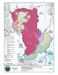
Clicking on the link above will take you to an interactive Solano Subbasin and GSA Boundaries map.
*Disclaimer: This is a working document and is intended exclusively for educational purposes and should not be construed as legal advice or a binding statement of the views of the local agencies involved in its drafting. This working document will be periodically updated to stay current with emerging SGMA regulations and the changing realities in the Solano Subbasin. For further clarification of SGMA regulations we recommend that you contact the California Department of Water Resources or the State Water Resources Control Board.
Contact
Solano Groundwater Sustainability Agency
810 Vaca Valley Parkway, Vacaville, CA 95688
Tel: 707.451.6090 Fax: 707.451.6099