Am I in the Solano Subasin?
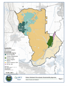
Below is a downloadable map of the Solano Subbasin and GSA boundaries.

Geology and Groundwater Resources
The Solano Subbasin includes the southernmost portion of the Sacramento Valley Groundwater Basin and extends into the northern portion of the Sacramento-San Joaquin Delta. The Solano Subbasin boundaries are defined by Putah Creek on the north, the Sacramento River on the East (from Sacramento to Walnut Grove), the North Mokelumne River on the southeast (from Walnut Grove to the San Joaquin River), the San Joaquin River on the South (from the North Mokelumne River to the Sacramento River), the Lower Members of the Great Valley Group on the Northwest, and the Suisun-Fairfield Valley Basin on the Southwest. The Solano Subbasin underlies the Cities of Vacaville, Dixon and Rio Vista, and is pumped extensively for local agricultural and municipal uses.
The Solano Subbasin of the Sacramento Valley Groundwater Basin occurs over the eastern half of Solano County in the southern Sacramento Valley, a portion of the larger Central or Great Valley geologic province of California. It has been reported on by federal, state and local entities, including the U.S. Geological Survey (USGS), United States Bureau of Reclamation, DWR and various hydrogeologic consulting firms as contracted by local municipalities for local investigations.
The Sacramento Valley has had tectonically subsiding sedimentary deposits through most of Cenozoic time. Within these sedimentary deposits, fresh groundwater extends to an elevation of -3,000 feet mean sea level (msl) along the axis of the basin. The freshwater aquifer system in the Solano Subbasin, includes a relatively thin alluvial aquifer underlain by the pre-Holocene Tehama formation. The Tehama formation has been differentiated into three segments, including upper, middle and basal zones. Each of these is characterized by patterns of lithology that reflect the processes that influenced their formation. The majority of current municipal groundwater production in the northern Solano Subbasin, including that of the City of Vacaville and Rural North Vacaville Water District, occurs from the basal zone of the Tehama formation. The middle and upper zones of the Tehama formation as well as the overlying alluvial aquifer are utilized on a more distributed basis by individual agricultural and domestic wells, outside of the municipal service areas. It is not currently understood the degree of confinement in the Alluvium and the upper zones of the Tehama, and this will continue to be investigated with further monitoring. The basal zone of the Tehama formation is a confined aquifer system and pumping from this zone results in rapid groundwater level responses.
Recharge of the alluvium comes from direct percolation of rainfall and return flows of applied water by agricultural and municipal users. Recharge of the Tehama Formation is believed to occur in the northwestern area of the County where the formation outcrops. A portion of the recharge to the basal Tehama may be due to leakage from the overlying Quaternary alluvium and upper zones of the Tehama Formation in the outcrop areas. Due to the limited groundwater level record, the ability of recharge from this area to replenish the larger regional basal zone in a timely manner is uncertain.
Solano Subbasin Conditions
Background
Groundwater conditions in the Solano Subbasin appear to be generally stable. Monitoring in the Subbasin shows short-term groundwater level fluctuations from spring to fall with rising levels occurring in response to groundwater recharge during the winter and lowering levels in the fall resulting from increased seasonal demands on groundwater during the summer. Longer-term trends in groundwater levels are also evident and occur in association with changing hydrologic conditions (i.e., wet and dry periods). for more information about Groundwater in the Solano Subbasin, read about Local Conditions, Geology and Groundwater Resources, and read answers to Frequently Asked Questions.
Monitoring
It is important to understand groundwater conditions in the Solano Subbasin. Agencies in the Subbasin have developed an extensive groundwater monitoring network to track groundwater conditions throughout the Subbasin. The Cities of Vacaville, Dixon, and Rio Vista, California Water Service-Dixon, Sacramento County, Northern Delta GSA, Solano Subbasin GSA, Maine Prairie Water District, Rural North Vacaville Water District, Solano Irrigation District, California Department of Water Resources, U.S. Geological Survey, U.S. Bureau of Reclamation, and Solano County Water Agency monitor numerous wells across the Subbasin for groundwater levels and water quality. Learn more at the Solano County Water Agency Groundwater Local Conditions Webpage.
The web map below displays conditions at different sites in the GSP monitoring network, including information on well type, depth and screen interval, approximate location, and observed water level or water quality conditions. The web map aims to provide information on groundwater conditions in the subbasin to help support the sustainable management of groundwater.

Groundwater Sustainability Annual Report
 The Annual Report provides an update on groundwater conditions in Solano County and the Solan Subbasin, with a summary of estimated water use and groundwater extractions in the Solano Subbasin in accordance with the SGMA requirements for GSP annual reporting. GSAs submit an Annual Report each April 1st. The Solano County and Subbasin Groundwater Sustainability Annual Report for the 2023 water year was submitted on April 1, 2024 to the Department of Water Resources.
- Groundwater Sustainability Annual Report – Water Year 2024
- Groundwater Sustainability Annual Report – Water Year 2023
- Groundwater Sustainability Annual Report – Water Year 2022
- Groundwater Sustainability Annual Report – Water Year 2021
View a snapshot of the Solano Subbasin water conditions in the 2024 The State of the Subbasin Infographic.

Clicking on the link above will take you to an interactive Solano Subbasin and GSA Boundaries map.